Introduction to Geospatial Modeling Environment
The Power of Geospatial Modeling the digital age, understanding the geographical context of data is paramount. The geospatial modeling environment serves as a critical framework for visualizing, analyzing, and interpreting data related to geographic locations. With advancements in technology, the way we collect, process, and utilize spatial data has transformed, enabling a range of applications that impact our daily lives and the environment around us.
Geospatial modeling allows decision-makers across various fields to visualize complex data in an accessible manner. This article delves deep into geospatial modeling, exploring its history, applications, technologies, challenges, and future potential.
Historical Significance
The roots of geospatial modeling can be traced back to ancient cartography. Early maps were vital for navigation and exploration, often hand-drawn and limited in scope. The evolution from these rudimentary maps to sophisticated digital models marks a significant leap in our ability to understand spatial relationships. Key developments such as the invention of the telephone and telegraph facilitated communication, while advancements in photography and satellite technology allowed for more accurate data collection.
The advent of Geographic Information Systems (GIS) in the 1960s marked a turning point in the field. GIS enabled the integration of spatial data with attribute data, providing a powerful tool for analysis and visualization. Today, geospatial modeling encompasses a wide range of technologies, including remote sensing, GPS, and advanced analytics, which collectively contribute to our understanding of complex spatial phenomena.
The Evolution of Geospatial Technology
Historical Context
Early Mapping Techniques
Mapping has been essential for civilization since ancient times. The earliest known maps date back to the Babylonian era, depicting celestial bodies and land boundaries. These maps served practical purposes, helping navigate trade routes and delineate territory. As societies evolved, so did mapping techniques, culminating in more sophisticated representations of geography.
Medieval maps, while often inaccurate, began to incorporate more artistic elements, reflecting the worldview of their creators. The Renaissance brought about significant advancements in cartography, including the use of perspective and scale. By the 17th century, maps were becoming more scientifically accurate, aided by the development of tools such as the compass and the sextant.
Advent of Geographic Information Systems
The late 20th century saw a paradigm shift with the introduction of GIS. This technology allowed for the layering of multiple data sources, enabling users to visualize relationships that were previously invisible. In the 1980s, the development of desktop GIS software made geospatial analysis accessible to a broader audience, transforming urban planning, environmental science, and public health.
GIS technology has continued to evolve, with the integration of real-time data and advanced analytical tools. The rise of open-source GIS software, such as QGIS, has further democratized access to geospatial technologies, allowing a wider range of users to engage in spatial analysis.
The Role of GIS
GIS Fundamentals
At its core, GIS is a system designed to capture, store, manipulate, analyze, manage, and present spatial or geographic data. GIS integrates various types of data, including raster (grid-based) and vector (point, line, polygon) data, making it a versatile tool for spatial analysis.
Key Components of GIS:
- Hardware: The physical devices used to run GIS software, including computers, servers, and GPS devices.
- Software: Programs that enable users to create, manage, and analyze spatial data. Common GIS software includes ArcGIS, QGIS, and GRASS GIS.
- Data: Geographic and attribute data that serve as the foundation for analysis. This includes satellite imagery, demographic data, and environmental data.
- People: Skilled professionals who interpret and analyze data, applying GIS tools to address real-world problems.
Applications of GIS
GIS applications are vast and varied, with significant implications across numerous fields:
- Urban Planning: Planners utilize GIS to visualize land use, assess infrastructure needs, and develop sustainable growth strategies. GIS enables planners to analyze demographic data, transportation networks, and environmental impacts, facilitating informed decision-making.
- Environmental Management: GIS plays a vital role in monitoring and managing natural resources. For example, environmental scientists use GIS to track changes in land cover, monitor wildlife habitats, and assess the impacts of climate change.
- Public Health: In public health, GIS helps track disease outbreaks, identify health disparities, and inform resource allocation. For instance, mapping the spread of infectious diseases can guide vaccination campaigns and public health interventions.
- Disaster Response: GIS is crucial for disaster management, providing tools to assess risks, plan evacuation routes, and allocate resources effectively during emergencies.
Key Components of the Geospatial Modeling Environment
Data Acquisition
Methods of Data Collection
The foundation of any successful geospatial modeling project lies in data acquisition. Various methods are employed to gather relevant spatial data, including:
- Remote Sensing: Utilizing satellites and aerial platforms, remote sensing captures images and data from the Earth’s surface, providing insights into land cover, vegetation, and urban development. For instance, NASA’s Landsat program has been pivotal in monitoring environmental changes over decades.
- Surveys: Ground-based surveys involve collecting data directly from the field, often using tools like GPS devices, total stations, and drones. Drones, in particular, have revolutionized data collection by providing high-resolution imagery and real-time data capture.
- Public Datasets: Many government agencies and organizations provide access to geospatial data, allowing researchers and practitioners to leverage existing information for their projects. Open data initiatives, such as the US Geological Survey’s Earth Explorer, offer valuable resources for environmental and geological studies.
Challenges in Data Acquisition
Despite the availability of various data collection methods, challenges remain. Incomplete or outdated datasets can lead to inaccuracies in analysis. Moreover, privacy concerns often restrict access to certain types of sensitive data, such as personal information tied to geographical locations. Ensuring data quality and reliability is essential for effective geospatial modeling.
Additionally, data from different sources may be incompatible, requiring careful integration and standardization. This process can be time-consuming and complex, particularly when dealing with large datasets.
Data Processing
Data Cleaning and Transformation
Once data is acquired, it must undergo processing to ensure it is ready for analysis. This stage involves cleaning and transforming the data, which includes:
- Removing inaccuracies: Identifying and correcting errors in the dataset, such as incorrect coordinates or attribute values.
- Filling in missing values: Utilizing statistical methods to estimate missing data points based on available information.
- Standardizing formats: Ensuring that all data is in a consistent format, which is crucial for accurate analysis.
The goal is to create a reliable dataset that can support meaningful analysis. Data processing is a critical step that often determines the success of a geospatial modeling project.
Software Tools
Numerous software tools are available for data processing in geospatial modeling, each with unique features and capabilities. Popular options include:
- ArcGIS: A comprehensive GIS software that offers extensive tools for spatial analysis and data visualization. ArcGIS Pro, the latest version, allows for 3D visualization and advanced analytics.
- QGIS: An open-source alternative to ArcGIS that provides many similar functionalities, making it accessible to a wider audience. QGIS supports numerous plugins that enhance its capabilities, allowing users to tailor the software to their specific needs.
- GRASS GIS: A powerful open-source GIS software that excels in raster processing and spatial modeling. GRASS GIS is particularly useful for researchers who require advanced analytical capabilities.
Spatial Analysis
Core Techniques
Spatial analysis lies at the heart of geospatial modeling. Various techniques are employed to explore spatial relationships and identify patterns:
- Overlay Analysis: This technique combines multiple layers of data to find correlations. For instance, overlaying land use data with demographic information can reveal trends in urban development. An example can be seen in urban heat island studies, where land cover types are overlaid with temperature data to assess the impact of urbanization.
- Buffer Analysis: Buffering creates zones around geographic features, allowing analysts to assess their impact on surrounding areas. This is particularly useful in environmental studies, where the influence of a pollutant can be examined. For instance, buffer analysis can be used to determine the impact of industrial facilities on nearby residential areas.
- Interpolation: Interpolation estimates values at unsampled locations based on known data points. It’s commonly used in climate modeling to predict temperature or precipitation levels across a region. Techniques such as Kriging and Inverse Distance Weighting (IDW) are frequently employed for this purpose.
- Network Analysis: This technique examines how spatial entities interact within a network, such as transportation or utility systems. Network analysis is crucial for optimizing routes and resource allocation. For example, public transportation planners can use network analysis to design efficient bus routes based on ridership patterns.
Practical Examples
Real-world applications of these techniques illustrate their power. For example, urban planners may use overlay analysis to evaluate how proposed developments could affect local ecosystems, while environmental scientists might employ interpolation to model air quality variations across a city.
In another example, public health officials may use buffer analysis to identify areas within a certain distance of healthcare facilities, helping to ensure equitable access to medical services.
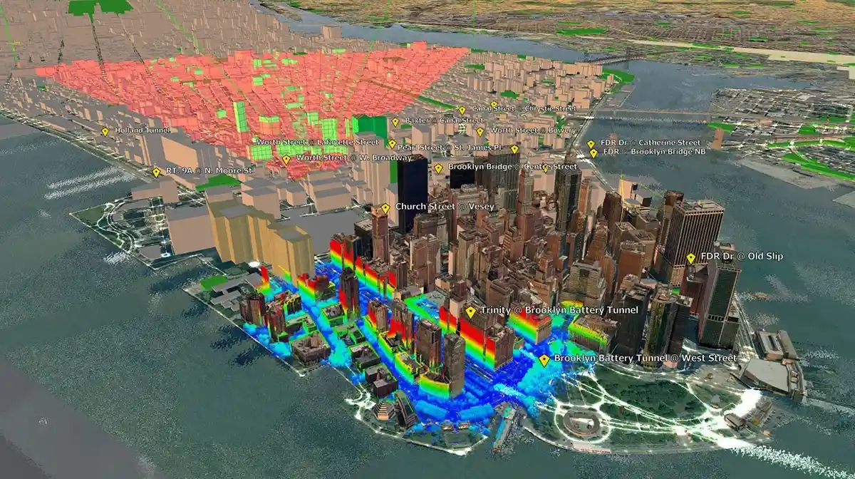
Applications of Geospatial Modeling
Urban Planning
Role of Geospatial Modeling in Urban Development
Urban planning relies heavily on geospatial modeling to visualize land use, assess infrastructure needs, and plan for sustainable growth. By integrating various datasets, planners can create detailed models that inform decision-making. These models help identify potential areas for development, assess the impact of new projects on existing infrastructure, and evaluate the effectiveness of zoning regulations.
Case Studies
Smart City Initiatives
Cities worldwide are adopting smart technologies to enhance urban living. For instance, Barcelona has implemented a smart lighting system that adjusts based on real-time data, reducing energy consumption and improving public safety. Geospatial modeling supports these initiatives by providing the necessary data to identify areas for improvement and monitor outcomes.
Another example is Singapore, which uses a comprehensive geospatial data platform to manage urban infrastructure. The city-state has developed a 3D digital twin of its urban environment, allowing planners to visualize and analyze proposed developments in real time. This innovative approach has helped Singapore become a leader in smart urban planning.
Environmental Management
Biodiversity and Habitat Conservation
Geospatial modeling is instrumental in environmental management, particularly in biodiversity conservation. By mapping habitats and species distributions, scientists can identify critical areas for protection. This information is vital for developing conservation strategies and assessing the impact of human activities on ecosystems.
For instance, the World Wildlife Fund (WWF) uses geospatial modeling to identify biodiversity hotspots, guiding conservation efforts in regions with high levels of endemic species. These models help prioritize areas for protection and inform policy decisions.
Climate Change Studies
As climate change poses significant challenges globally, geospatial modeling offers tools to analyze its impacts. For example, researchers can use geospatial models to assess the vulnerability of coastal areas to rising sea levels, guiding policy decisions for disaster preparedness and resource allocation.
An illustrative case is the use of geospatial modeling in the assessment of flood risks in New Orleans after Hurricane Katrina. By analyzing topographic data, precipitation patterns, and historical flood events, scientists were able to identify areas at risk of future flooding, informing infrastructure improvements and emergency response plans.
Disaster Management
Risk Assessment and Preparedness
Geospatial modeling plays a crucial role in disaster management by enabling authorities to assess risks and develop preparedness plans. By analyzing historical data and current conditions, decision-makers can identify high-risk areas and implement strategies to mitigate potential disasters.
For example, during hurricane season, geospatial models can predict storm surge impacts, allowing emergency management officials to develop evacuation plans and allocate resources effectively.
Real-Time Data Applications
The integration of real-time data into geospatial models enhances situational awareness during emergencies. For instance, during wildfires, geospatial modeling can provide updated information on fire spread and containment efforts, helping responders allocate resources effectively and inform the public.
One notable example is the use of geospatial technology during the 2018 Camp Fire in California. Emergency responders utilized real-time satellite imagery and mapping tools to track the fire’s progression, identify evacuation routes, and coordinate firefighting efforts.
Transportation and Logistics
Optimizing Transportation Networks
Geospatial modeling is essential in transportation planning and logistics management. By analyzing traffic patterns, road networks, and population density, planners can optimize transportation systems for efficiency and sustainability.
For instance, cities like London and New York utilize geospatial modeling to analyze traffic congestion and identify areas where infrastructure improvements are needed. By visualizing traffic patterns, city planners can develop strategies to alleviate congestion and enhance public transportation.
Case Study on Smart Transportation Systems
In cities like Los Angeles, geospatial modeling supports the development of smart transportation systems. By integrating real-time traffic data with GIS, officials can monitor congestion and adjust traffic signals dynamically, improving flow and reducing delays.
The city has implemented an adaptive traffic control system that utilizes geospatial data to optimize traffic signal timings based on current conditions. This innovative approach has resulted in decreased travel times and improved air quality by reducing vehicle emissions.
Health and Epidemiology
Mapping Disease Spread
Geospatial modeling is a valuable tool in public health, enabling researchers to track disease outbreaks and identify patterns in transmission. By mapping disease spread, health officials can implement targeted interventions and allocate resources effectively.
For example, during the COVID-19 pandemic, public health officials relied on geospatial models to visualize the spread of the virus, identify hotspots, and inform public health policies. These models helped guide decisions regarding lockdown measures and vaccination campaigns.
Environmental Health Studies
Environmental health studies benefit from geospatial modeling by assessing the impact of environmental factors on human health. For example, researchers may analyze the relationship between air quality and respiratory illnesses in urban populations, informing public health policies.
One case study involved the use of geospatial modeling to assess the impact of air pollution on asthma rates in children living in urban areas. By correlating air quality data with health records, researchers identified high-risk neighborhoods, leading to targeted interventions aimed at reducing exposure to pollutants.
Challenges in Geospatial Modeling
Data Quality and Availability
Ensuring Data Integrity
Data quality is paramount in geospatial modeling. Poor-quality data can lead to erroneous conclusions and misguided decisions. To ensure data integrity, practitioners must implement rigorous quality control measures throughout the data acquisition and processing stages.
This includes regularly updating datasets, verifying sources, and employing statistical methods to identify outliers and inconsistencies. The accuracy of geospatial models is directly tied to the quality of the underlying data, making this a critical consideration in any modeling project.
Accessing Geospatial Data
While many datasets are publicly available, access to high-quality geospatial data can be limited. Proprietary datasets, in particular, may restrict research efforts. Advocating for open data initiatives can help democratize access and foster collaboration among researchers and practitioners.
Additionally, the rapid pace of technological advancement can create disparities in data access. Emerging technologies such as LiDAR and satellite imagery offer unparalleled detail, but the costs associated with these datasets can be prohibitive for some organizations, particularly in developing countries.
Complexity of Spatial Relationships
Understanding Interconnectedness
Spatial relationships are often complex, with various factors influencing outcomes. For instance, the interplay between socioeconomic factors, land use, and environmental conditions can create intricate dynamics. Accurately modeling these relationships requires advanced analytical techniques and a deep understanding of the underlying systems.
To navigate this complexity, researchers often employ interdisciplinary approaches, integrating insights from fields such as sociology, economics, and environmental science. By considering multiple perspectives, practitioners can develop more robust geospatial models.
Advanced Analytical Techniques
To address the complexity of spatial relationships, researchers increasingly turn to advanced techniques such as spatial statistics and machine learning. These methods allow for more nuanced analyses, enabling practitioners to uncover hidden patterns and make informed decisions.
For example, machine learning algorithms can analyze vast amounts of geospatial data to identify correlations and predict future trends. This capability has applications in urban planning, environmental monitoring, and disaster management, among other fields.
The Future of Geospatial Modeling
Integration with AI and Machine Learning
Enhancing Data Analysis
The integration of artificial intelligence (AI) and machine learning (ML) into geospatial modeling represents a significant advancement in the field. These technologies can enhance data analysis by automating processes, improving predictive modeling, and enabling more sophisticated spatial analyses.
Machine learning algorithms can be trained to recognize patterns in geospatial data, allowing for more accurate predictions and insights. For instance, AI-driven predictive models can forecast traffic patterns, identify areas at risk of flooding, and assess the impact of land use changes on biodiversity.
Case Studies
One notable example of AI integration is the use of convolutional neural networks (CNNs) for land cover classification using satellite imagery. Researchers have achieved impressive accuracy levels by training CNNs to identify different land cover types, enabling more efficient monitoring of land use changes over time.
Another case study involves the application of machine learning in public health. Researchers have used geospatial modeling combined with AI to predict the spread of infectious diseases based on environmental factors and population movement patterns, leading to more effective intervention strategies.
Real-Time Data Integration
IoT and Geospatial Modeling
The Internet of Things (IoT) is revolutionizing the collection of real-time geospatial data. Connected devices, sensors, and smart technologies generate vast amounts of data that can be integrated into geospatial models. This integration enhances the accuracy and relevance of analyses, allowing for more dynamic and responsive decision-making.
For example, smart city initiatives leverage IoT devices to collect real-time data on traffic conditions, air quality, and energy consumption. This data can be fed into geospatial models, enabling city planners to make informed decisions based on current conditions rather than relying solely on historical data.
Future Applications
As IoT technologies continue to advance, the potential applications of real-time geospatial modeling will expand. Smart cities, for instance, will increasingly rely on real-time data to optimize resource allocation, monitor environmental conditions, and enhance public services.
One future application involves the use of real-time geospatial data to enhance disaster response efforts. By integrating data from various sources, such as weather sensors and social media, emergency responders can gain a more comprehensive understanding of unfolding events, enabling faster and more effective responses.
Open Data Initiatives
The rise of open data initiatives is democratizing access to geospatial data. Governments, organizations, and institutions are increasingly sharing datasets with the public, fostering collaboration and innovation. This trend has the potential to empower researchers, activists, and communities to engage in spatial analysis and advocate for positive change.
Platforms like Data.gov and OpenStreetMap exemplify the benefits of open data initiatives. These platforms allow users to access a wealth of geospatial data, facilitating research, planning, and community engagement. The availability of open data can lead to increased transparency, improved decision-making, and enhanced public participation in governance.
Conclusion
The geospatial modeling environment is a powerful tool that transforms raw data into meaningful insights. By leveraging advanced technologies and analytical techniques, we can better understand our world, make informed decisions, and tackle complex challenges. As the field continues to evolve, the potential applications of geospatial modeling will expand, unlocking new opportunities for innovation and discovery.
Call to Action
To harness the full potential of geospatial modeling, it’s essential for organizations and individuals to invest in training, technology, and data quality. Collaboration between researchers, practitioners, and policymakers is crucial in developing innovative solutions that leverage geospatial data for societal benefit. As we look to the future, embracing the power of geospatial modeling will be key to addressing the pressing challenges of our time.for more details please visit the website networksights.com


Leave a Reply